Exploring the Canary Islands in 2026 means moving through active rift zones, lava terraces, and rugged coastal cliffs with real-time hazard awareness. You’ll follow established routes, monitor heat signatures, gas emissions, and seismic cues, and rely on layered alerts and PPE. Field notes, GPS/InSAR data, and drone mapping guide your decisions, while rangers enforce restricted zones and safety gaps. Expect rapid landscape changes, ash-rich beaches, and evolving emergency protocols—more on this evolving safety framework awaits you.
Key Takeaways
- Real-time monitoring data (seismic, gas, GPS, InSAR) informs safe access and route planning for volcanic landscapes in 2026.
- High-resolution satellite imagery supports rapid mapping of lava flows, tremor activity, and hazard zones for visitors.
- Guided routes emphasize lava textures (pāhoehoe, aā), fracture networks, and coastal cliff features while avoiding unstable areas.
- Ecological and cultural sites, including lava-adapted habitats and ancestral landscapes, are integrated into conservation and interpretation programs.
- Visitor protocols include PPE, dosimeters, restricted zones, and crisis communication to ensure safe, culturally respectful exploration.
Canary Islands: A Living Volcanic Landscape
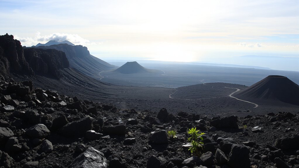
The Canary Islands are a living volcanic terrain shaped by ongoing magmatic activity and rapid landscape change. You examine active rift zones, noting crustal movement and subsidence that reconfigure coastlines and gullies within hours to days.
Field data emphasize hazard-aware awareness: you map lava flow margins, tremor swarms, and gas emissions to predict paths and vent evolution. In study sites, you document lava formations, distinguishing pāhoehoe and aā textures, while recording river incision into cooled flows that reveals timing of emplacement.
Volcanic legends inform cultural context, but you separate myth from mechanism, anchoring interpretations in geologic processes. You integrate satellite and ground truth measurements to constrain eruption probability and lava advance rates, guiding early warning thresholds and hazard mitigation planning.
Teide National Park: Geology and Access
Teide National Park sits at the heart of the Canary Islands’ volcanic system, where recent eruptions and ongoing magmatic activity shape a high-altitude, lava-dominated landscape.
You assess rock exposures, noting distinct volcanic minerals that record eruptive phases, crystallization paths, and degassing histories.
Access routes prioritize safety: maintained roads, guided corridors, and controlled cable-parks for summit approaches, with clear warnings for altitude, sudden weather shifts, and wind-laden lava fields.
You monitor seismic alerts, crater rim temperatures, and fumarolic plumes as part of daily field checks.
Geologic interpretation emphasizes stratigraphy, caldera remnants, and lava-flow morphologies that influence trail conditions.
The area’s geothermal energy potential is considered within regulatory constraints, ensuring field activities don’t impede geothermal resource integrity or visitor safety.
La Palma Calderas: Monitoring and Trails
You’ll engage with Calderas monitoring techniques, from real-time seismic and gas sensing to ground deformation measurements, to track activity levels and inform hazard alerts.
Trail accessibility updates are essential for planning routes, with closures and rehabilitated paths clearly communicated to minimize exposure to unstable ground or sudden venting.
Prioritize visitor safety by following posted guidance, using personal protective gear where required, and reporting any unusual ground movement or ash emissions to authorities.
Calderas Monitoring Techniques
Calderas on La Palma require a rigorous, multi-sensor monitoring approach, combining ground deformation data, seismicity, gas emissions, and visual observations to detect precursory signals of unrest. You’ll rely on GPS networks, InSAR analyses, and tiltmeters to track deformation patterns linked to magma or hydrothermal pressure changes.
Seismic monitoring detects swarm activity, long-period events, and tremor associated with conduit fluid movement. Gas flux measurements, including CO2 and SO2, help interpret magmatic versus hydrothermal sources, while photography and drone surveys document surface changes.
Data fusion enables timely hazard assessments and informs evacuation and access decisions. Caldera formations and erosion processes shape expectations for future unrest, so you emphasize baseline stability and rapid response planning, ensuring field crews can operate safely within evolving deformation and emission regimes.
Trails Accessibility Updates
Trails accessibility on La Palma’s caldera rim must reflect ongoing monitoring results and evolving hazard assessments. You evaluate route viability through real-time deformation data, seismic alerts, and gas emissions before marking segments as open, restricted, or rerouted.
In this update, you prioritize access that minimizes exposure to ash ladders, unstable rims, and sudden vent activity while preserving core loops for long-term study. You document trail conditions, surface stability, and drainage performance with standardized checklists and geotagged photos, enabling rapid reallocations when alerts rise.
You integrate cultural traditions and local cuisine awareness into visitor briefings, highlighting historically used paths and seasonal harvest tracks without compromising safety. You balance accessibility with hazard awareness, ensuring that trail networks support ongoing research while protecting communities and landscapes.
Visitor Safety Measures
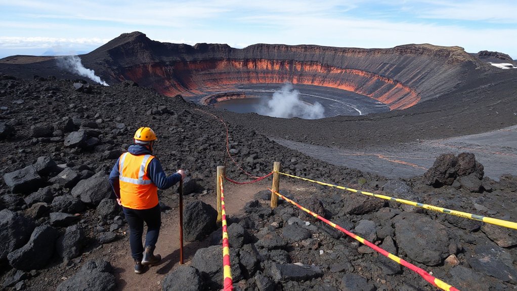
Visitor safety on La Palma’s calderas combines real-time monitoring with proactive on-site protocols to minimize risk while maintaining access for study and visitation. You’ll encounter layered alert systems, geotechnical sensors, and temporary closures when gas emissions or ground deformation exceed thresholds.
Trail design emphasizes stable routes, rockfall protection, and periodic condition checks performed by trained rangers. Before you step onto a path, review current hazard notices, wear PPE as required, and carry a charged beacon or radio.
Cultural heritage sites along routes are protected; observe signage and restricted zones to preserve integrity. Local cuisine stops may be curated near visitor centers, but safety remains primary.
Report unfamiliar activity promptly to authorities to sustain access while honoring field constraints and ecological stewardship.
Lanzarote’s Volcanic Art: Timanfaya and the Lava Landscape
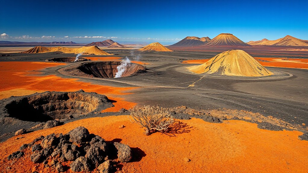
Lanzarote’s Timanfaya National Park presents a stark, moonlike lava landscape shaped by successive eruptions in the 18th century, where basaltic flows and hipothetical pyrolav erupted to form a layered terrain that remains volcanically active in microclimate and soil chemistry.
You assess the field records, noting how fracture networks channel heat, sustaining surface hygroscopic pockets and crustal instability underfoot. The terrain informs ongoing hazard assessments: loose tephra, radiant heat, and sudden venting require strict visitor spacing and monitoring.
This setting also preserves cultural traces, including Volcanic myths that frame local interpretation of lava as living history. As you map features, you document Lava art—scoria sculpture, glassy bombs, and color bands—that illustrate eruptive processes while supporting interpretive safety messaging.
Lanzarote’s Lesser Cones: Exploring Cueva De Los Verdes and Surrounding Cones
Cueva de los Verdes and the surrounding cones form a compact, accessible corridor into Lanzarote’s subterranean volcanism, where cooled lava tubes intersect with fresh volcanic features to reveal conduit dynamics, fracture networks, and perched moisture zones.
You assess cave geometry under field conditions, noting active degassing risk, footing variability, and limited daylight. Cave exploration emphasizes route choice, bolt placements, and communication plans to minimize exposure during guided visits.
Surrounding cone formations exhibit intrusive and eruptive sequences that shape skylines, collapse pits, and ventilation pathways. You document stratigraphy, mineralization, and moisture regimes to interpret past eruption styles while maintaining hazard awareness for tourists and researchers.
Maintain conservative pacing, monitor thermal cues, and avoid overconfident traverses when crustal surfaces remain unstable.
Monitor Eruptions: Sensors, Satellites, and Early Warnings
Sensors, satellites, and early-warning systems form the backbone of eruption monitoring in Canary Island contexts, linking field observations from cone fields and lava tubes to near-real-time situational awareness.
You deploy dense sensor networks, ground deformation gauges, and gas sensors to quantify magmatic pressurization and effusive trends.
Remote sensing via high-resolution satellites provides rapid mapping of lava fountains, plume height, and flow front velocity, enabling timely hazard assessments.
Data fusion supports crisis decision-making, evacuation triggers, and risk communication for residents and visitors.
In volcanic tourism zones, operators coordinate with authorities to interpret alerts, preserving safety while supporting lava photography opportunities during quiescent to moderate activity.
Maintain log integrity, verify anomalies, and document warning-response cycles for continuous improvement.
Safe Access in Volcanic Zones: Entry Rules and Safety Gear
Access to volcanic zones requires strict adherence to established entry rules and personal protective equipment (PPE) standards to minimize exposure to gases, heat, and ballistic hazards. In practice, you’ll follow defined routes, obtain permits, and check current activity status before stepping onto marked paths.
PPE should include certified respirators or gas masks, eye protection, flame-resistant clothing, gloves, and sturdy boots with ankle support. You must carry a dosimeter for gas exposure and a reliable communication device for rapid alerts.
Monitor wind shifts and stay within designated safety zones; stray incursions increase risk from sudden venting. This is essential for responsible volcanic tourism, where safety protocols protect you and teammates, while preserving delicate landscapes for future researchers and visitors.
Remain disciplined, report anomalies, and respect posted restrictions at all times.
Moonlit Lava Fields: Night Hikes and Stargazing
Moonlit lava fields offer a stark, technically demanding setting for night hikes and stargazing, where low light and uneven terrain amplify risk. You move with deliberate steps, using a headlamp tuned to preserve night vision and prevent glare. Assess footing for irregular lava crust, loose gravel, and hidden cracks; test each step before committing.
Equipment should include gaiters, sturdy boots, and a compact beacon for emergency signaling. Lunar landscapes reveal sharp contrasts; stay within marked routes, and avoid glossy surfaces that hide hazards. Night safaris require disciplined pacing, hydration, and constant situational awareness of shifting ground and volcanic heat signatures.
Observe skies only after thermal checks, preventing heat-spot confusion during long exposure. Preserve darkness for fellow observers and document sightings succinctly.
Coastal Cliffs and Black Sands: Geology, Ecology, and Conservation
Coastal cliffs of the Canary Islands expose a dynamic interface between basaltic lava flows and ocean erosion, forming steep faces, sea stacks, and ash-rich beaches. You assess rock stability, fracture networks, and wave-cut platforms to interpret erosion rates and post-volcanic history.
Coastal erosion shapes cliff retreat, exposes vesicular basalt, and concentrates rubble hazards at footpaths and lookout points, demanding integrated monitoring and risk signage. You document stratigraphy, tephra layers, and marine terrace formation to infer paleoclimate and sediment yield.
Marine biodiversity hinges on littoral habitats, including tidal pools and intertidal platforms, which sustain endemic invertebrates and foraging seabirds. Conservation priorities require restricted access during weather-driven instability, seasonal nesting windows, and sediment transport management to balance public access with ecosystem resilience.
Lava-Adapted Ecosystems and Endemic Species to Spot
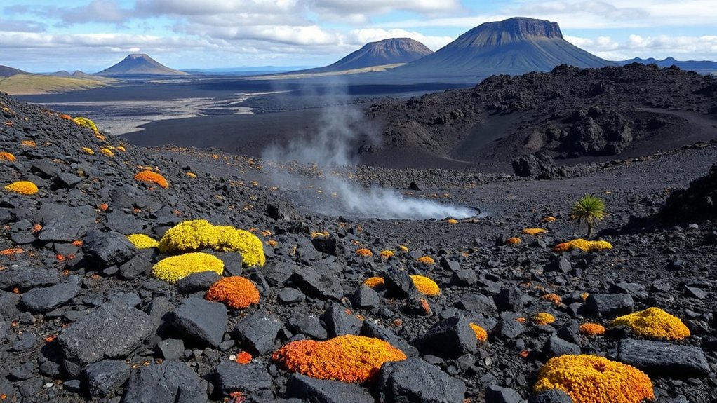
You’ll assess lava-adapted flora across distinct habitats, noting how volcanic soils shape plant communities and resilience to soda, ash, and wind.
Look for endemic species hotspots where rapid colonization meets soil storms, and document their survival strategies in active and recently erupted terrains.
This field-oriented scan emphasizes hazard awareness while mapping biodiversity tied to volcanic substrates.
Lava-Adapted Flora Habitats
Lava flow fronts harbor microhabitats with heat pockets, while subsequent cooling generates fragmented substrates that favor crustose, moss-dominated communities and vascular pioneers tolerant of desiccation. Monitor for Volcanic ash layers that alter soil chemistry, moisture retention, and germination cues, shaping successional trajectories.
Track erosion risk, pocket vegetation, and refugia on lava tubes or fractured walls. Emphasize hazard awareness, wearable protection, and standardized transects to compare post-eruption recovery across islands.
Endemic Species Hotspots
You map persistence risk by documenting colonization rates, spectral soil warmth, and moisture pulses after eruptions, prioritizing sites with repeated disturbance but stable microclimates. You integrate field notes with rapid assessments of population structure, telemetry-ready marking, and predator pressure, maintaining hazard-awareness for fumarole zones and unstable clinker fields.
You frame management around Volcanic tourism and endemic conservation, emphasizing minimal footprint monitoring, seasonal access windows, and data-informed protection of delicate keystone endemics. You communicate findings to agencies, researchers, and local communities.
Volcanic Soils & Biodiversity
Volcanic soils shape biodiversity in dynamic, substrate-driven mosaics where recent lava flows create rapid opportunities for pioneer plant and microbial communities, followed by gradual soil development that scaffolds lava-adapted faunas.
You observe how Volcanic soils influence nutrient pulses, water retention, and microbial networks that seed succession, while erosion and ash deposits create distinct microhabitats.
In practice, you map biodiversity hotspots by integrating soil texture, pH, trace elements, and mineralogy with vegetation surveys and invertebrate traps.
You’ll note endemism concentrates near shielded lava tubes and kipukas, where stable soils persist.
Field hazard awareness remains essential: unstable crusts, gas emissions, and sudden reprofiling events can alter habitats rapidly.
This integration clarifies how Volcanic soils sustain Biodiversity hotspots across island gradients, guiding conservation and restoration priorities.
People and Power: Indigenous Cultures, Mining, and Historic Eruptions
The Canary Islands’ volcanic regions have shaped Indigenous practices, mining histories, and responses to eruptions through time, revealing how communities adapt governance, risk assessment, and resource use to dynamic hazards.
You observe how Indigenous rituals informed land tenure and seasonal mining cycles, integrating eruptive risk with daily decision-making, while colonial and modern institutions reframe authority, insurance, and resource rights.
You document historic eruptions as calibration events for hydraulic, social, and architectural resilience, noting how early societies embedded hazard awareness into kinship networks and territorial memory.
Indigenous rituals and cultural festivals preserve paleo-seismic knowledge, guiding settlement and resource dispersion under evolving hazard regimes.
Your field notes emphasize cross-cutting governance, mining practices, and eruption response as intertwined systems.
Conservation and Visitor Impact: Balancing Access With Preservation
You assess how visitor footprints alter fragile volcanic ecosystems and where trampling or off-trail routes risk erosion or habitat disturbance.
With protected area access, you weigh permit systems, timed entries, and infrastructure to concentrate impact away from sensitive sites.
Your goal is to establish monitoring, boundary clarity, and hazard-aware design that sustains access while preserving the landscape for long-term resilience.
Visitor Footprint Management
Managed access is essential to minimize disturbance while sustaining ecosystem resilience on Canary Island volcanoes. You implement trail design that concentrates flow, reducing off-trail damage and soil erosion in high-use zones.
By classifying routes by hazard potential and seasonal risk, you enforce caps on daily visitors and time-slots for sensitive sites, decreasing tourist congestion without compromising scientific value.
You integrate monitoring sensors, periodic vegetation assessments, and visitor counts to adjust permits in near real-time, ensuring early detection of impact thresholds.
Emphasize low-impact behaviors in briefing materials, fostering a culture of responsibility that supports Cultural preservation while allowing meaningful exposure to volcanic processes.
Your management plan prioritizes emergency-ready access, clear wayfinding, and rapid response protocols to keep both people and habitats safe.
Protected Area Access
Implement staged permits, seasonal closures for nesting or eruptive indicators, and clear wayfinding that reduces inadvertent trampling of hañas and lapízar fields. You integrate hazard-aware protocols, including remote alerts, PPE requirements, and rapid egress routes for high-risk zones.
Emphasize Cultural preservation in interpretive materials to respect ancestral landscapes, while ensuring Local communities participate in decision frameworks and benefit from sustainable visitation.
Your plan aligns conservation targets with research access, balancing preservation priorities with responsible exploration and transparent accountability.
Planning a 2026 Volcanic Itinerary: Best Seasons and Routes
Planning a 2026 volcanic itinerary requires aligning climate windows with eruption and access hazards while prioritizing field safety. You’ll target periods with stable winds and minimal rainfall to reduce rockfall risk and mudflow exposure, while avoiding recent seismic swarms.
Route selection emphasizes established trails, official permits, and low-traffic corridors near summit craters and coastal lava fields. Seasonal windows differ by island: spring’s moderate temps aid long-day observations, while autumn crests offer clearer skies but higher wind potential.
Schedule flexible contingency for sudden venting or restricted access. Include stops at interpretive viewpoints, noting volcanic myths and lava stories to contextualize formations without altering field priorities.
Document conditions, hazard alerts, and escape options, ensuring communication plans with local rangers and rescue services. Always respect restricted zones and preserve fragile surfaces.
Tech-Enabled Exploration: Drones, Apps, and Field Guides
You’ll leverage drone mapping techniques to rapidly document lava flows, crater rims, and fault lines with georeferenced accuracy under variable wind and ash conditions.
Field guide apps will guide safety protocols, track specimens, and provide offline access to hazard scales and eruption histories, ensuring you stay current even where connectivity fails.
Real-time data tools tie sensor feeds to situational awareness, enabling you to adapt routes and sampling plans on the fly while maintaining rigorous data quality.
Drone Mapping Techniques
- Drone technology enables rapid data capture across rugged slopes and crater rims.
- Mapping precision improves when high-resolution imagery is paired with ground control points.
- Workflow integrates flight planning, radiometric calibration, and robust post-processing.
- Outputs support volume estimates, lava-flow delineation, and change detection over time.
Field Guide Apps
Apps synchronize topographic basemaps, recent thermal imagery, and multi-parameter alerts, enabling rapid risk assessment before entering crater rims or lava-terrace zones.
Digital navigation features guide you along established routes, while offline caches guarantee reliability when signal is intermittent.
Augmented reality overlays visualize fault lines, unstable ground, and safe ingress corridors over your field view, reducing misinterpretation.
You’ll document observations, timestamped annotations, and geotagged samples, supporting post-field analysis.
Prioritize conservative decision thresholds, verify data provenance, and maintain redundancy to ensure field safety and data integrity.
Real-Time Data Tools
- Drone-assisted viewpoints deliver high-frequency situational awareness across crater rims and lava flows.
- Mobile apps centralize geotagged observations, sensor readings, and incident logs for rapid sharing.
- Field guides integrated offline guarantee continuity when network access is limited.
- Automated anomaly detection flags unusual activity for timely field verification.
What’s Next for Canary Volcanic Futures
The Canary Islands’ volcanic outlook hinges on proactive monitoring, integrated hazard assessment, and adaptive risk governance as seismic, magmatic, and hydrothermal signals evolve across the archipelago. You’ll navigate forward by prioritizing real-time data fusion, interoperable alerts, and robust field calibration, ensuring rapid decision-making under uncertainty.
In practical terms, anticipate phased risk-reduction measures, targeted surveillance of magma supply, and continuous assessment of vent activity, gas emissions, and ground deformation. You’ll also examine the social license for emergency planning, tourism resilience, and infrastructure hardening, aligning local expertise with regional strategies.
Volcanic legends shape public perception, but scientific communication must remain precise and accessible. Geothermal energy prospects offer co-venture opportunities, yet require rigorous permeability and reservoir assessments before scaling deployment.
Frequently Asked Questions
How Crowded Are Canary Islands Volcano Hotspots in Peak Seasons?
Peak-season crowds at Canary Island volcano hotspots are moderate to high; expect congestion near major lava tours. Plan early, book guides, and prioritize safety. Volcanic tourism demands caution, wear protective gear, and choose official operators for lava tours.
Are There Restricted Zones Near Major Eruption Sites?
Volatile vistas validate vigilance: you’ll encounter restricted zones near major eruption sites. You must follow volcano eruption monitoring updates and adhere to restricted zone regulations, prioritizing safety, staying informed, and respecting controlled access during hazardous activity.
What Safety Gear Is Essential for Volcanic Hikes?
You should wear protective footwear and carry emergency supplies; for volcanic hikes, prioritize sturdy boots with ankle support, moisture-wicking layers, gloves, eye protection, a helmet, a respirator or mask, and a compact first-aid kit. Stay alert, train, plan ahead.
Can Drones Be Used in Protected Volcanic Landscapes?
Can you fly a drone here? Yes, but adhere to drone regulations and avoid wildlife disturbance; you must obtain permits, respect protected zones, and monitor wind/ash hazards to prevent impact on habitats and safety.
What Are the Best Weather Windows for Lava-Field Visits?
Best weather windows for lava-field visits occur when winds are light, storms absent, and humidity moderate; monitor volcanic activity alerts. You’ll assess volcanic geology and lava composition on-site, prioritize hazard awareness, and calibrate timing to safe access and imaging conditions.
Conclusion
Despite the awe, you stay grounded in hazard awareness. In 2024–25 seismic swarms on La Palma hovered near 4–6 events per week, underscoring ongoing instability even as trails reopen. You’ll navigate Teide’s summit routes, Timanfaya’s crustal features, and Cueva de los Verdes with real-time alerts, drone-captured mapping, and conservation protocols. The statistic grabs attention: small magma intrusions and gas flux shifts can alter accessibility within hours. Plan flexible schedules, respect closures, and prioritize safety alongside discovery.