Exploring the volcanic landscapes of the Canary Islands lets you trace a persistent mantle plume shaping shield-building eruptions and layered lava sequences across several islands. You’ll observe how vent alignments, eruption pauses, and crustal growth record mantle dynamics, crustal strength, and surface reshaping. Texture variations—from glassy sheens to needle-like crystals—reveal eruption styles, cooling rates, and gas escape. Teide, La Palma, and El Hierro show recent activity patterns, while safety-minded routes promise insights you’ll gain as you continue.
Key Takeaways
- The Canary Islands showcase shield volcanoes formed over a long hotspot track, with layered lava flows and varied textures revealing eruption styles and cooling histories.
- Lava textures and basaltic surfaces record rapid solidification, gas escape, and weathering features like iron oxides and calcite halos shaping the landscape.
- Volcanic maps and vent alignments illustrate mantle plume influence, crustal movement, and sequential eruptive episodes across islands.
- Recent activity on La Palma and El Hierro, including seismic swarms and ground uplift, highlights ongoing magma movement and hazard monitoring importance.
- Integrated monitoring—surface deformation, seismicity, and geochemistry—improves eruption forecasts and hazard mitigation for visitors exploring volcanic terrains.
Foundations: How the Canary Islands Formed
The Canary Islands formed when a series of volcanic plumes rose from a tectonic hotspot under the Canary Basin, creating shield volcanoes that built the archipelago over millions of years. You observe how buoyant magma fed extensive lava flows, resurfacing basalts and creating a broad, stepped basaltic platform.
This foundational process concentrates volcanic minerals within proximal crustal zones, yielding distinct geochemical signatures across islands. You note alignment of vents and eruptive pauses that reflect mantle source consistency and plate motion over time.
Lava formations vary from phase-to-phase eruptions, forming layered sequences, feeder dikes, and mafic lobes. The result is a coherent stratigraphy that communicates eruption frequency, magma viscosity, and crustal response, establishing the archipelago’s persistent geomorphology and guiding subsequent interpretation of tectonic controls.
Volcanoes by Island: The Canary Archipelago’s Geologic Map
You’ll examine how each island’s volcanic record forms a distinct segment of the Canary Archipelago’s geologic map, linking timing and style of eruptions to tectonic context.
By aligning the Geological Timeline By Island with Island-Specific Volcanic Features, you can compare spatial patterns, recurrence intervals, and magma evolution across the archipelago.
This map-based eruption history sets up a framework to analyze differences in crustal structure, eruptive styles, and post-eruption modification on each island.
Geological Timeline By Island
Across the Canary Islands, volcanic activity unfolds as a series of island-specific timelines, each capturing distinct eruptive episodes, mantle processes, and surface reshaping events. You examine how timelines differ by island, linking eruption rate changes to underlying magma supply, crustal strengths, and tectonic stress.
The map reveals sequence logic: shield-building phases, flank instability, caldera collapse, and renewed venting as magma evolves. You assess temporal gaps, calibration methods, and dating uncertainties, translating raw data into comparable chronologies.
Volcanic symbolism emerges in the rock record as persistent motifs—summits, lava flows, and rift alignments—that recapitulate mantle dynamics. Lava mythology surfaces in interpretations of eruption style shifts and gas signatures, guiding hypotheses about mantle source variation and storage.
This timeline framework sharpens your understanding of volcanic evolution across the archipelago.
Island-Specific Volcanic Features
Isolating each island’s volcanic feature set reveals distinct control by magma supply, crustal thickness, and tectonic setting, shaping eruption styles and landform evolution across the Canary Archipelago. You examine island-specific features by parsing lava pathways, vent alignments, and summit and rift systems, noting how Magma pockets feed shield or stratovolcano shapes.
Volcanic soil characteristics reflect eruption recurrence and weathering rates, informing soil-chemistry profiles and fertility potential. On each island, lava formations record eruption style—thin pāhoehoe flows versus blocky aa—and crustal responses to loading and unloading.
You assess vent morphology, fissure patterns, and edifice growth to infer mantle source variations and crystallization histories. The synthesis highlights how local plumbing governs surface expressions, influencing landscape stability and ecological niches across archipelago volcanic terranes.
Map-Based Eruption History
The geologic map of the Canary Islands reveals a coherent eruption history when you trace each island’s volcanic units, vent alignments, and age progressions across time. You observe how mapped lava flows, intrusive bodies, and stratigraphic boundaries encode sequential activity, showing pulses of volcanism that shift with subsidence and uplift.
By comparing lava formations to vent patterns, you infer eruption styles, magma supply, and crustal controls that shaped each island’s trajectory. The map also highlights Variscan and post-arc influences, tying volcanic myths to geologic events while remaining strictly evidence-based.
You identify gaps, constrain ages, and test hypotheses about mantle plumes, tectonics, and surface processes that drive long-term island evolution.
- Volcanic myths
- Lava formations
- Eruption sequencing
- Vent alignment patterns
- Temporal clustering
The Visual Language of Canary Lava: From Basalt to Black Sands
The visual language of Canary lava unfolds from molten basalt to the gloss of black sands, revealing a progression shaped by cooling rates, mineral content, and weathering. You examine surface signatures that encode eruption style, flow viscosity, and rapid solidification, then translate texture into history.
Lava textures emerge as diagnostic fingerprints: glassy sheens where quenching was abrupt, needle-like crystals in cooled cores, and fine vesicular lattices where gases escaped. Basalt’s dark uniformity contrasts with peppered iron oxides and calcite halos that weather the rock, signaling age and exposure.
This field becomes a study in volcanic symbolism, where color, crust, and grain size communicate process. You synthesize observations into a coherent narrative, linking petrology to landscape form without overinterpretation, maintaining precise, technically grounded reasoning.
Tenerife’s Teide: What This Peak Teaches Us About Eruptions
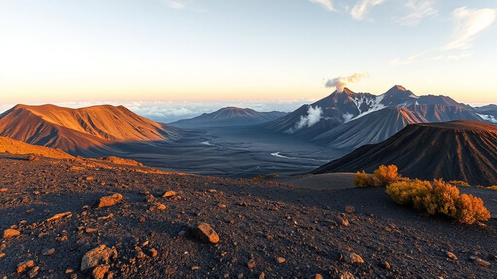
Teide’s eruptive history offers a tangible case study in recognizing patterns of activity, including changes in venting, magma supply, and eruption style. You’ll see how regional tectonics shape eruption sequences, and how Teide’s behavior informs broader interpretations of risk and monitoring in volcanic arcs.
This discussion centers on Eruptive Behavior Patterns and Teide’s Geological Lessons to illuminate why eruption dynamics matter for prediction and preparedness.
Eruptive Behavior Patterns
Tenerife’s Teide offers a clear window into eruptive behavior patterns, revealing how magma supply, chamber dynamics, and surface processes interact to produce intermittent bursts and long quiet intervals. You observe that eruption styles shift with pressure, volatile content, and conduit morphology, creating alternating phases of effusive lava flow and explosive fragmentation.
Volcanic gases evolve as magma viscosity changes, guiding fragmentation thresholds and plume characteristics. Seismic signals accompany magma movement, while deformation reveals pressure build‑up and release cycles. The pattern isn’t random; it follows reservoir recharge, crustal response, and volatile exsolution, yielding quasi‑cyclic activity with variable durations.
This framework helps predict potential progressions between quiet periods and renewed unrest, informing monitoring strategies and hazard assessments.
- Volcanic gases and pressure dynamics
- Eruption styles and fragmentation thresholds
- Seismicity as a timing indicator
- Deformation revealing chamber processes
- Recharge, exsolution, and flow interactions
Teide’s Geological Lessons
Despite its fame, Teide isn’t just a towering silhouette; it functions as a natural lab for parsing eruption dynamics. You observe how summit swelling tracks magma supply, while flank movements reveal stress redistribution.
Teide’s layered products record a shift from effusive to intermittent explosive behavior, offering a time-lapse of Tenerife’s magmatic evolution. You analyze lava composition to distinguish primary magma batches, detect mixing, and map crystallization histories that constrain eruption timelines.
The high-alpine setting stresses cooling rates, vesicle formation, and gas exsolution, refining models of chamber pressurization. You confront volcanic myths with quantitative signals, separating cultural narratives from geophysical signals.
Teide teaches that monitoring surface deformation, seismicity, and geochemistry together yields robust eruption forecasts, transforming lore into verifiable, actionable science for hazard mitigation.
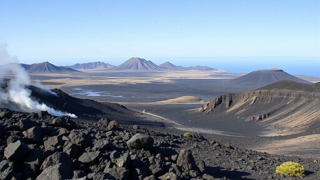
Lanzarote’s Fire-Spun Landscape: Timeless Flows and Luna-Lava Features
Lanzarote’s lava-formed terrain reveals a fire-spun landscape where basaltic flows master the surface, cooling into sharp ridges and glassy pavements that still bear the imprint of rapid, flowing eruptions. You observe how luna-lava features record quiet, persistent deformation, revealing a steady energy budget and low-viscosity magma pathways.
The terrain emphasizes pit states, flow fronts, and vesicular textures that mark eruptive efficiency, while stabilized surfaces hint at pauses between pulses. You assess lava formations as a chronicle of conduit geometry, eruptive magnitude, and cooling rates, where myths persist alongside measurements, shaping local eruption myths with tangible remnants.
This site exemplifies how geology and culture intertwine, presenting a precise, testable portrait of volcanic timing and landscape evolution.
- Lava formations
- Eruption myths
- Flow-front morphology
- Vesiculation patterns
- Cooling-rate indicators
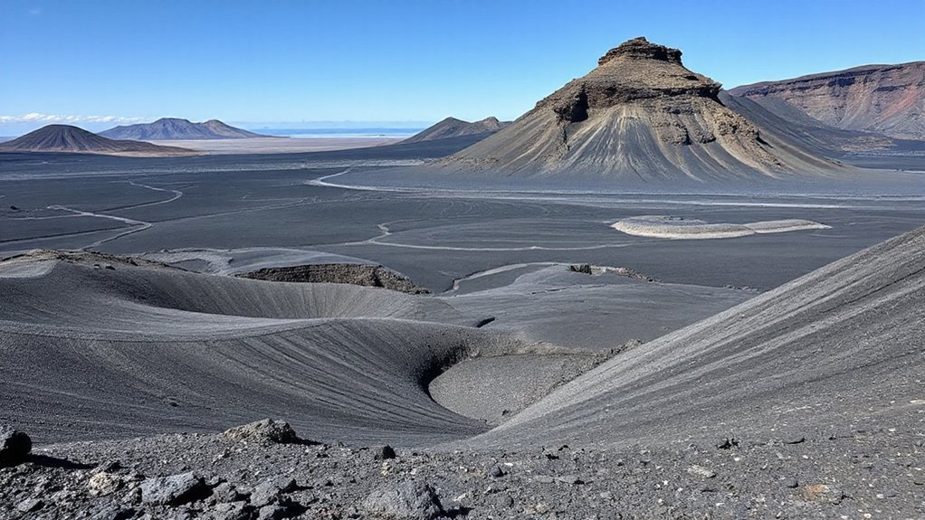
La Palma and El Hierro: Recent Activity and Ongoing Renewal
How have La Palma and El Hierro evolved in recent volcanic episodes, and what does renewed activity reveal about their internal plumbing and surface resilience? You observe subtle shifts in magma ascent, shallow reservoir pressures, and crustal responses that accompany eruptions.
Seismic swarms signal magma movement, while ground uplift marks inflation patterns near rift zones. You note that renewed activity exposes both persistent weakness zones and adaptive surface cooling, with intermittent lava effusion and renewed ash emissions shaping proximal landscapes.
Volcanic ash dispersal and deposition tests air quality and fringe ecosystems, while lava formations record eruption tempo and magma composition. Together, these signatures indicate a dynamic, stratified plumbing system, capable of reactivating harnessed conduits and reinforcing structural resilience through rapid crustal remodeling and surface stabilization.
Choosing Safe Volcano Trails: Criteria and Practical Tips
Choosing safe volcano trails requires a clear, evidence-based approach: you should evaluate current activity, terrain hazards, and response plans before you commit. You’ll assess geologic alerts, pave paths, and exits, then align your plan with local guidance and weather constraints.
Terrain varies from loose ash to solid lava, so expect unstable footing and sudden shifts in visibility. Prioritize routes with established trail markers and accessible evacuation routes, and carry appropriate safety gear for first aid and shelter.
A disciplined, conservative mindset reduces risk and improves decision-making under changing conditions.
- Check current activity notices and official advisories
- Verify trail markers and signed detours before departing
- Pack first aid, communication devices, and shelter items
- Plan escape routes for rapid evacuation
- Respect restricted zones and weather vulnerabilities
Underground Wonders: Lava Tubes, Caves, and Craters by Island
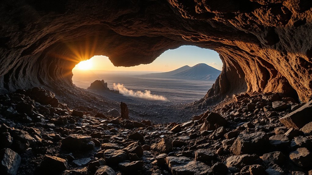
From safe-trail planning to subterranean exploration, the Canary Islands’ lava tubes, caves, and craters offer a different kind of volcanic exposure. You assess each island’s underground network by formation type, flow history, and accessibility.
Lava tubes reveal hollow conduits from former eruptions, with ceilings shaped by cooling, and floors stratified by sediment inflow. Mysterious cave formations often indicate past magma dynamics, while stalactite-like features mark long chemical interaction with moisture.
You examine cave morphology, noting collapse risks, ventilation patterns, and microclimates that influence traversal timing. Hidden underground chambers emerge where secondary vents and branch passages suspend further exploration.
Planning Your Route: Best Itineraries for Volcanic Landscapes
Planning your route through the Canary Islands’ volcanic landscapes requires a clear, data-driven approach: map key features by island, assess accessibility and time windows, and align your itinerary with safety margins and study goals.
- Prioritize islands with well-mapped volcanic minerals and accessible trailheads to maximize data collection while minimizing risk.
- Schedule viewpoints and hikes around volcanic activity alerts and seasonal weather windows.
- Cross-reference eruption myths with geologic timelines to enrich context without delaying logistics.
- Build redundancy into travel segments to accommodate closures or disrupted transport.
- Use a modular routing approach so you can reconfigure days quickly if new field observations emerge.
Frequently Asked Questions
Are There Hidden Safety Risks on Volcanic Beaches?
Hidden safety risks exist on volcanic beaches; you should stay alert. Beach safety requires constant hazard awareness, noting sudden rockfalls, unstable slopes, sharp cobbles, and volatile gases. Monitor warnings, tides, and eruption updates, and carry proper protective gear.
How Climate Changes Affect Eruption Patterns Long-Term?
Like a clockwork heart, you’ll see climate impact altering eruption frequency over time. You observe that higher heat and moisture shifts modulate magma behavior, so you quantify trends, correlate data, and assess long-term risks in climate-driven patterns.
Which Islands Have the Youngest Lava Flows?
You ask which islands have the youngest lava flows; Lava age and eruption history show El Hierro and La Palma as youngest, with recent eruptions. You observe recent lava ages, noting ongoing activity informs eruption history and hazard assessment.
Can You Still Observe Active Fumaroles Today?
Yes, you can still observe active fumaroles today. You’ll note volcanic gases venting, with fumarole monitoring showing episodic emission changes, plume color shifts, and temperature spikes indicating ongoing subsurface processes.
Do Local Legends Explain Each Lava Field’s Origin?
Yes, legends attribute each lava field to Mythical origins, shaping Cultural significance as communities interpret eruptions. You observe patterns, compare myths with geological records, and analyze how stories reflect ancestral connections, while evaluating evidence for symbolic versus literal explanations.
Conclusion
You leave with a sharper map of fire beneath the sea and ash on the wind. The Canary Islands reveal a landscape shaped by slow motion and sudden bursts, a geological conversation you can hear if you listen closely. Imagine Teide’s plume as a clock hand—each eruption a precise tick. In your notes, you’ll cite 7–9 on the basalt-to-sand spectrum, plus safety tips you’ll actually use on shaded lava tubes and crater rims. Observe, analyze, and choose with care.